Replacing planes with trains from Japan to Jakarta
This was originally presented as a YouTube video in December 2023
When we talk about “impractically big infrastructure megaprojects” to drive modal shift from air to rail, one of the go-to topics is the idea of a Transatlantic Tunnel. Not the 1935 movie, but the idea that has been explored in various documentaries that you could build a submerged tunnel between, for example, London and New York, evacuate it to reduce drag, and run maglev trains at a few thousand kilometres per hour through them, giving transit times far better than planes, and fueled entirely by green electricity. Put them more than 50m below the surface, and they won’t be affected by weather, nor by fishing or shipping.
The idea of such a tunnel has long preoccupied my rail fantasies. However, as someone who is nominally a scientist, so cares about decisions being backed by some kind of data, and so I went to look at Wikipedia’s list of the top passenger flight routes by passenger numbers. Believe it or not, no Europe–US route makes it into the top ten, and only one makes it into the top fifty. Even if we say that the Europe–US traffic is spread across many source and destination airports, we still encounter an issue: within the US and Europe, people still take short-haul flights, so even if a tunnel were built, most passengers would need to fly to get to and from the termini. Given that short-haul flights are the most polluting per passenger kilometre, this seems like the reverse of what we need to be doing.
Let’s look at the top ten now:
- Jeju–Seoul
- Sapporo-Tokyo
- Fukuoka–Tokyo
- Hanoi–Ho Chi Minh City
- Sydney–Melbourne
- Jeddah–Riyadh
- Tokyo–Naha
- Mumbai–Delhi
- Beijing–Shanghai
- Guanzhou–Shanghai
Spot anything conspicuous? None of these is in the Western hemisphere, and 7 out of 10 are in East Asia! Expanding out to the top 57, 36 are in East or Southeast Asia. Connecting these up, close as they are, will likely take far less effort than a single route crossing an ocean with dozens of unproven technologies.
Looking more closely, and we see something else: some of these routes are already served by high-speed rail. Tokyo–Fukuoka for example is a one-seat ride on a very comfortable Shinkansen, with no need to go through airport security, and good access to the city centre at both ends. So why are so many people still flying this route? I would argue that the primary consideration is time. Even giving rail the best handicap we can, starting and ending from Tokyo and Hakata stations, the Shinkansen at 299 minutes still takes over an hour longer than the flight option from Haneda to Fukuoka, plus check-in and connections. We need to find a way to make trains go faster, for longer. As luck would have it, Japan has been working on just that.
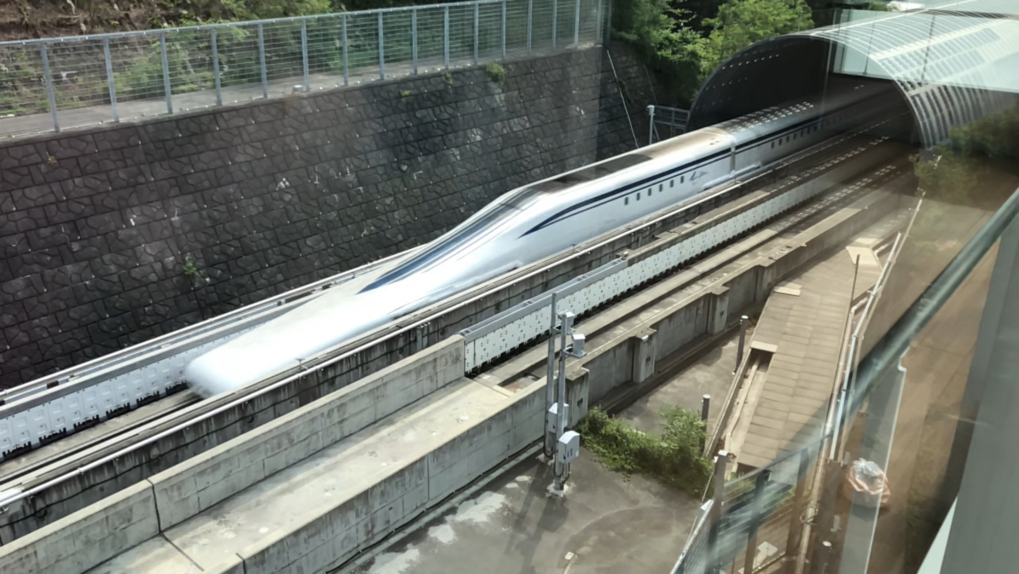
The linear Chūō Shinkansen is designed to run at 500km/h in everyday usage, and has hit a top speed of over 600km/h in tests. (Given the amount that high-speed rail top speeds have increased since the initial introduction of the Shinkansen, I’d hope this number will go up.) Currently under construction from Tokyo to Nagoya (delayed by, among other things, one intransigent prefecture blocking construction of an incredibly short section in the middle), the current intention is to subsequently continue on to Osaka. This effectively doubles the current Tokaido Shinkansen, the busiest in Japan, and a route that is still in the top 50 busiest passenger air routes. Hopefully this extra speed—significantly less than two hours station to station—will finally kill off the last few flights on that route.
But this clearly doesn’t go far enough. We need to keep the tunnelling going west from Osaka, and north from Tokyo. How far can we get? My proposal is a phased approach, each phase not going too far beyond what we have already proven technologically, but each building on the previous. Let’s take a look at our starting point.
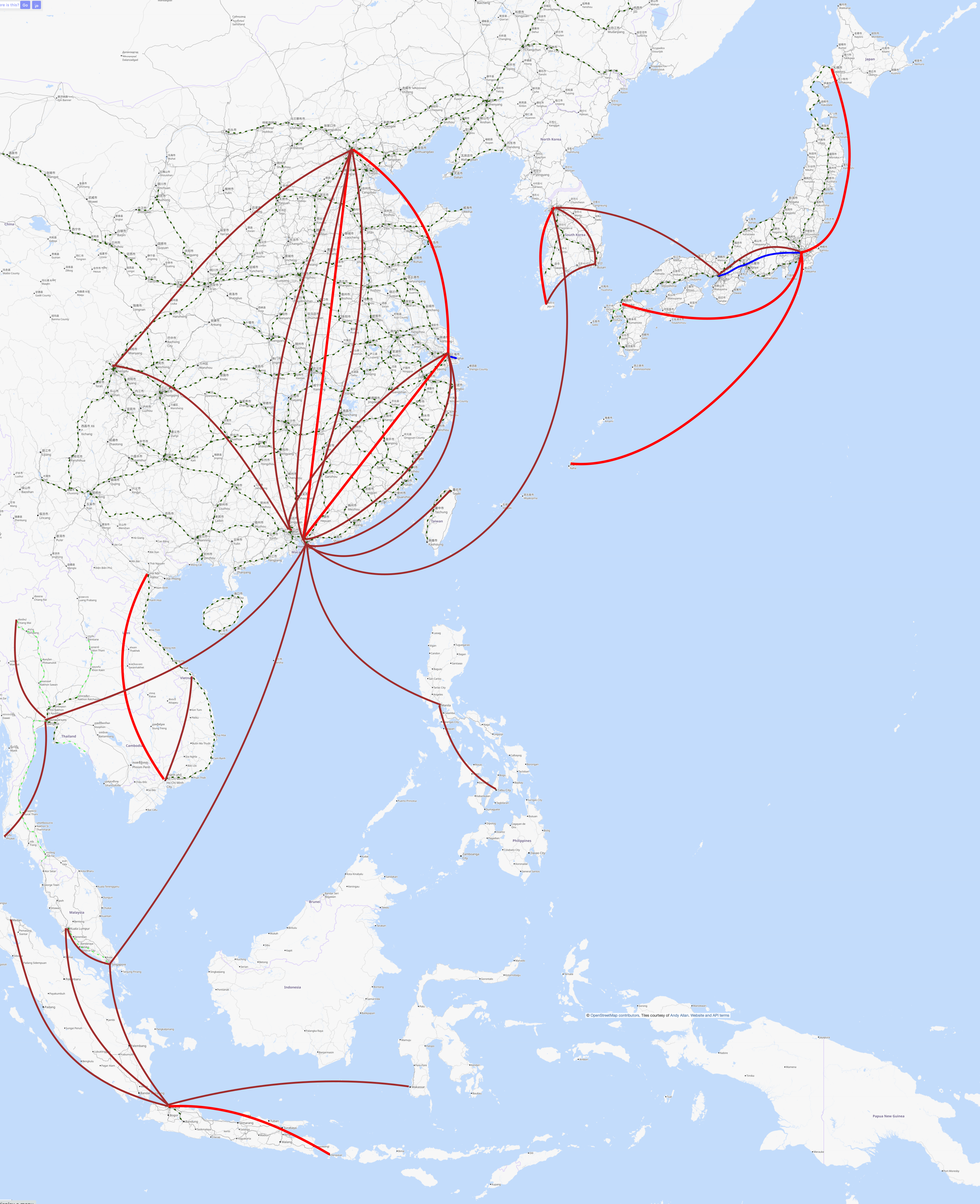
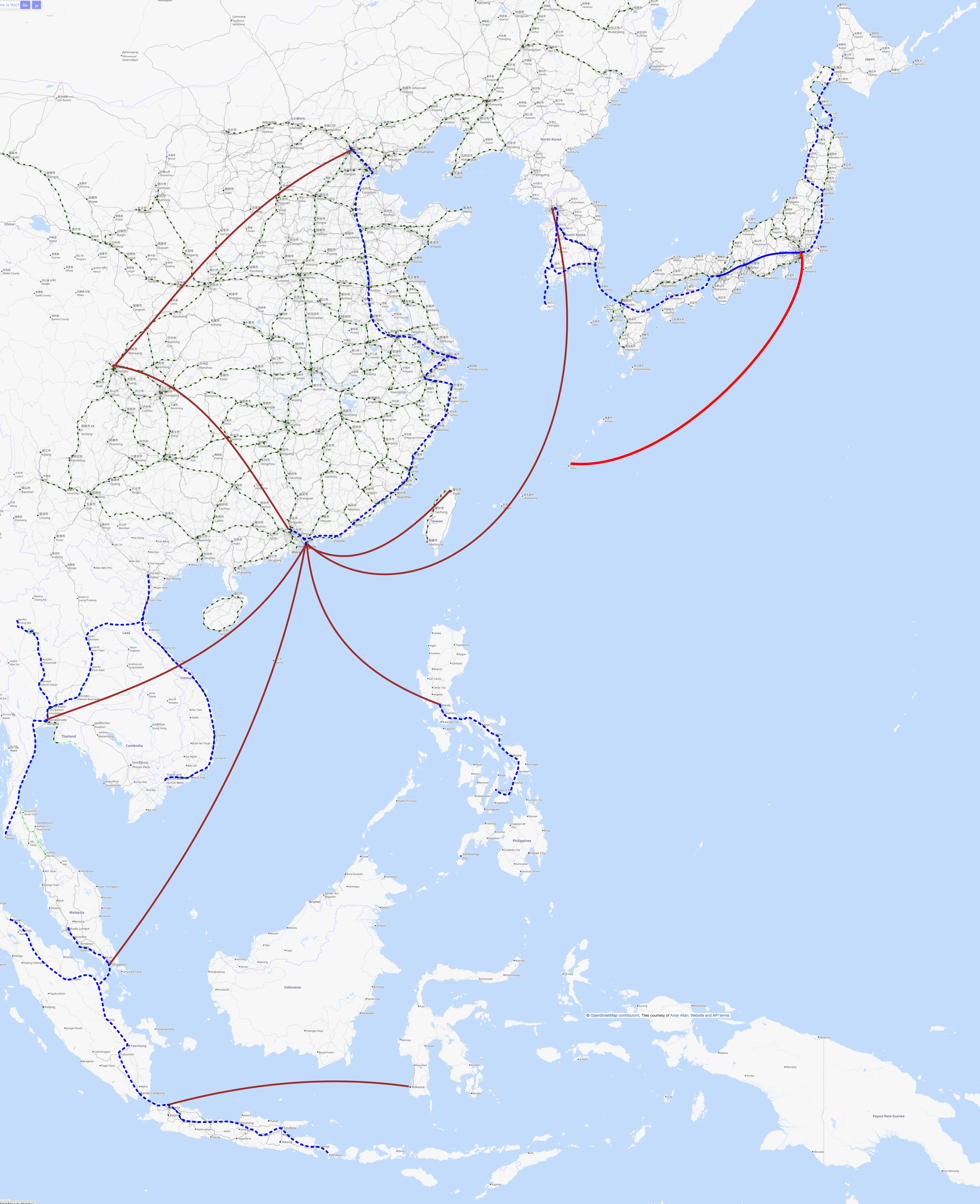
In bright red are the top 10 flight routes (including some bonuses in China, where multiple of the top 57 are almost identical routes, and the total passenger count would place them in the top 10). In darker red are the next 47. Two blue lines show the current 500km/h capable maglev lines: the Chūō Shinkansen under construction, and a short connection to Shanghai Airport. In dashed dark green are any high-speed lines, either operational or with a reasonable chance of being constructed soon, and in paler green are planned high-speed rail routes that seem less likely to actually be finished.
Phase 1
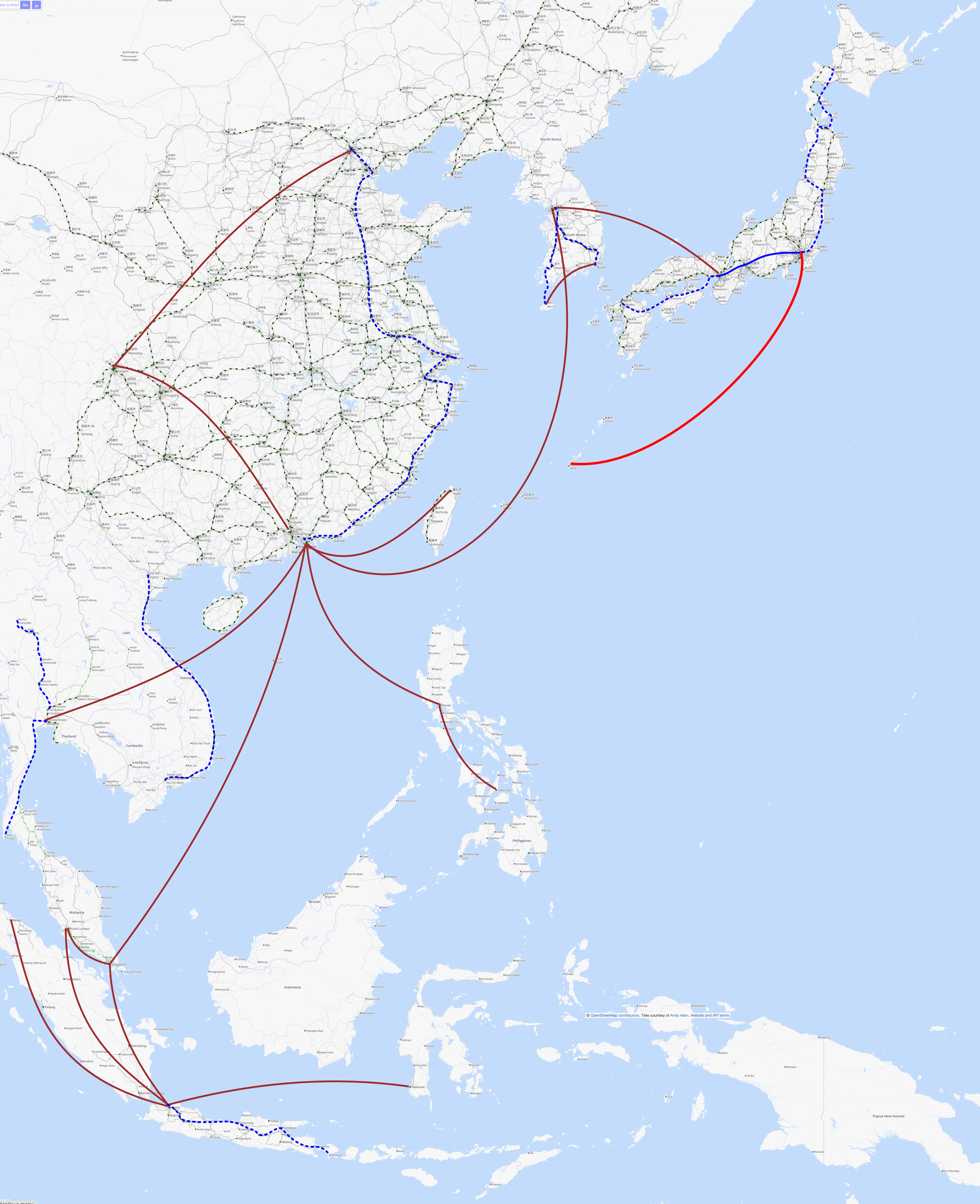
Let’s start off in Japan, as that’s the part of East Asia I’m most familiar with. From Tokyo, unlike the current Shinkansen which has no through service, we’ll continue the Chūō Shinkansen to the east, calling at Narita Airport, before heading north. I think it’s important to pick up the traffic from Narita here, as many countries with high-speed rail still have short-haul internal flights for passengers connecting from incoming long-haul flights, who don’t want to navigate across a foreign city that isn’t their destination, just to access the HSR station. (Having made this rail connection in Seoul travelling to Busan, I can empathise with this; it definitely made the travel trickier!) From Narita, then we head north to Sendai, but then head over to take the north west coast, currently only served by mini-Shinkansen, before crossing paths with the current Shinkansen in Aomori. From there, take a new route via Hakodate to Sapporo, to be slightly more direct, and avoid putting all eggs in one Seikan Tunnel-shaped basket. (It will also provide valuable experience and trained staff in undersea tunnelling, which will be needed in later phases!) This should strike off the Tokyo–Sapporo route from the top 10. At the other end of the Chūō Shinkansen, keep going west from Osaka to Kobe, but rather than following the San’yo Shinkansen along the south coast of Honshu, instead we cross to Shikoku, the only of Japan’s four main islands to not have any Shinkansen connections, and from there cross via Oita to Fukuoka. This rough route already exists in the basic plan for the Shinkansen, although building it has been postponed indefinitely. In addition to flights Tokyo–Fukuoka from the top 10, this will take a lot of local car traffic off the roads, in a region that is quite car-reliant.
Now we hop over to Korea, another area with high-speed rail that has not completely displaced flights. The first line goes Seoul–Busan, duplicating the existing HSR line, but faster. This takes off a relatively high ranking top 57 route. The second route branches off this near Cheonan, and heads south to the island of Jeju. Currently there is high-speed rail on most of this stretch, but there has been opposition (and budgetary limitations) blocking a tunnel to Jeju itself. Given the danger posed by rising sea levels to small islands, I think any local opposition due to “reducing the island character” needs to be viewed with extreme skepticism, given that this route is the number one passenger flight route in the world by passenger count. This route has the longest undersea tunnel proposed in this phase, but not one substantially longer than the longest undersea rail tunnels built to date.
Moving over to China, one long line from Beijing to Hong Kong via Shanghai covers almost all of the highly-trafficked internal flights in China. I aimed to take in populous cities on the route, but I’ve largely followed existing high-speed rail, both because I don’t know the country as well, and because China’s high-speed rail network is already so dense.
Further south, there is in principle already high-speed rail under construction in Vietnam, but given the distances involved, there’s no way it will be competitive with flying from Hanoi to Ho Chi Minh City. Vietnam is sufficiently long and thin that there’s little option but to follow the current rail and planned high-speed rail corridor here.
Further west in Thailand, the story is similar, although while there are planned high-speed rail routes from Bangkok to Chiang Mai and Phukhet, their build dates are uncertain, with routes heading east from Bangkok being prioritised instead. Perhaps this is informed by road usage rather than flights; to get planes out of the sky, Phukhet–Bangkok–Chiang Mai is essential.
Finally for phase 1, Indonesia being comprised of many islands makes rail harder than for some nations, but the flight Jakarta–Denpasar only crosses a very narrow strait, so should be achievable, and will connect many communities along the route currently without any high-speed public transit.
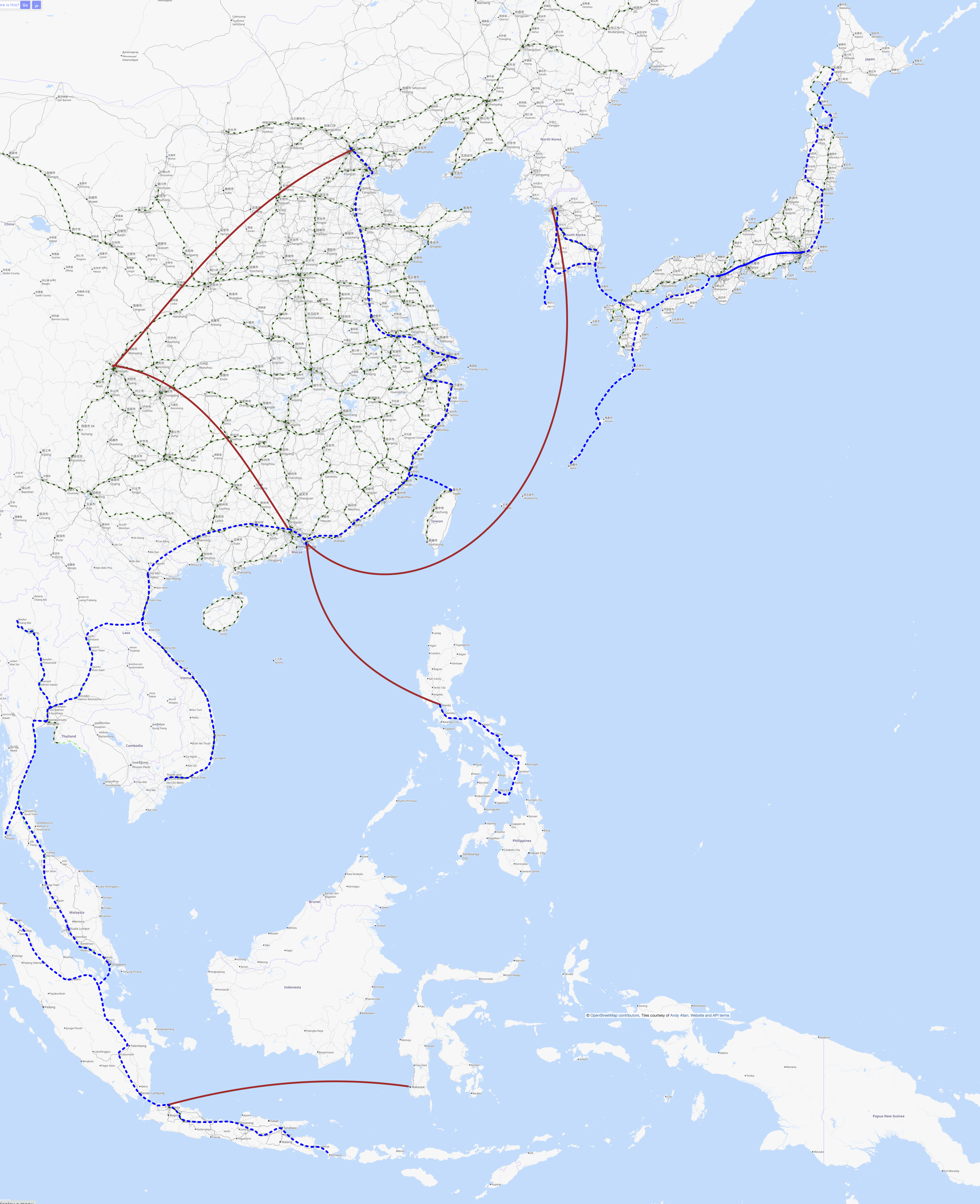
Phase 1a
Depending on how Phase 1 is received, there are a couple of additions that may be necessary to displace flights, but may not, so it makes sense to take a “wait and see” approach.
Firstly, a connection along the south coast of South Korea, to more directly link Busan to Jeju. In principle Phase 1 allows this, but going via Cheonan may be too far for travellers to choose it over flying.
Secondly, a link from Hong Kong to Guangzhou. It might be that the existing high-speed rail is sufficiently fast for travellers to be willing to change trains in Shenzhen, but a direct connection may be necessary to shift away from some Shanghai–Guangzhou and Beijing–Guangzhou flights.
Thirdly, Singapore and Malaysia have been in an on-again off-again relationship regarding a high-speed rail connection from Kuala Lumpur to Singapore for many years. Since I’m envisioning this project as a relatively authoritarian “world government decides there will be maglev on this corridor, and makes it happen” affair, if Malaysia and Singapore don’t get their acts together and get their high speed rail built, then imposing a faster solution externally might be the best way to drive modal shift on that route, and knock off another of the 57 most trafficked flight routes.

Phase 2
Phase 2 only takes out two flight routes, but they’re important ones to build capability for future phases.
Firstly, an undersea connection from Fukuoka to Busan via Tsushima, with through connections from Tokyo and Osaka to Seoul, takes out a big chunk of Japan–Korea traffic. Going via Ikinoshima and Tsushima means that the longest underwater segment is only double the longest from Phase 1. While still a technical (and political) challenge, this seems far more achievable than a slightly more direct route going under the sea all the way.
Secondly, a connection from Medan to Jakarta, including a long route down Sumatra, and an undersea connection Sumatra–Java, takes out one highly trafficked flight route, and also sets things up for more interconnectivity in later phases. Again, some island hopping here can help with avoiding too long a straight-shot undersea connection.
While each of the undersea tunnels is longer in this phase, the total length of underwater tunnelling is similar to phase 1; combined with the much lower total length than phase 1, this phase isn’t inherently more unachievable.
Phase 3
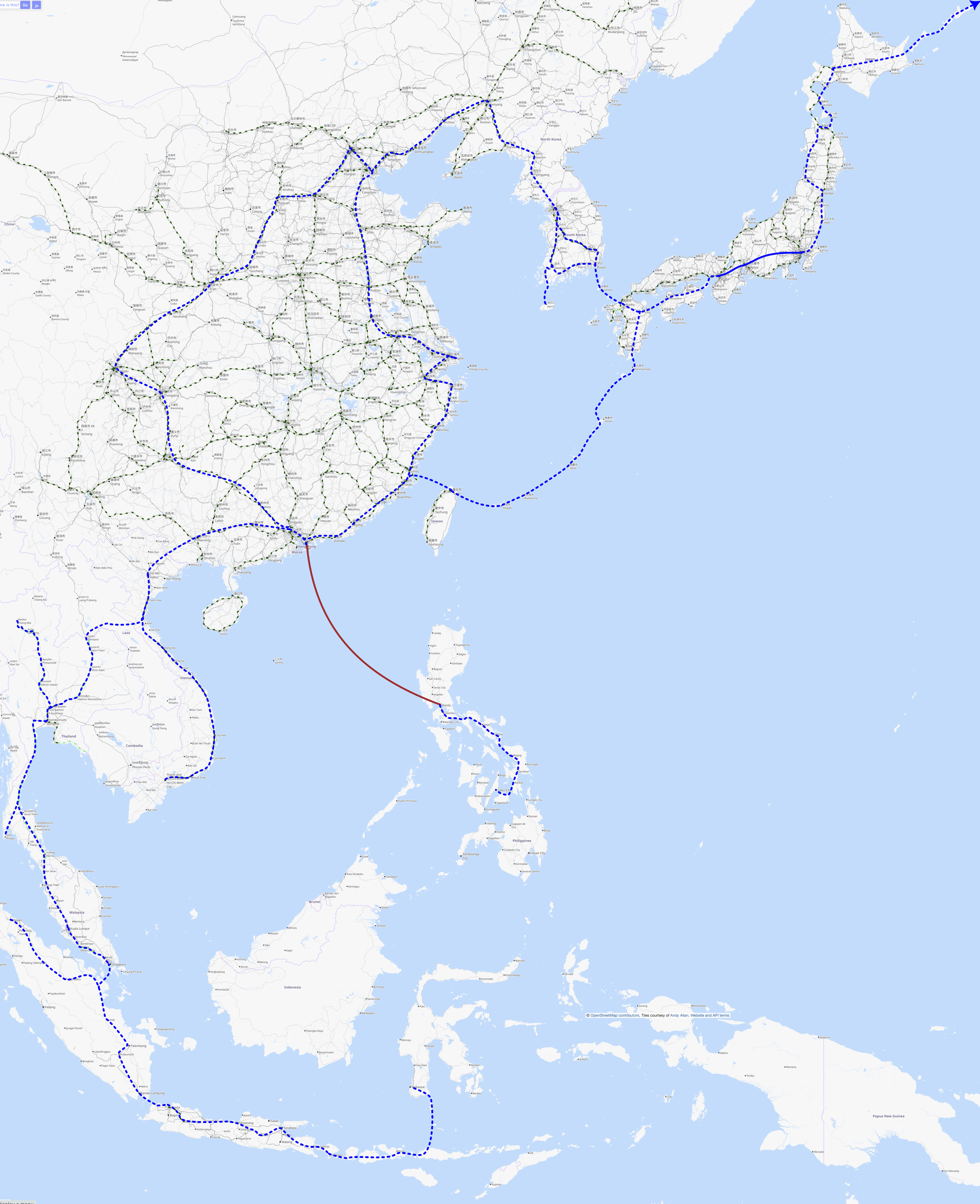
Phase 3 focuses further on Southeast Asia, and builds on the experience of undersea tunnelling from the first two phases, with three new connections.
Firstly, the phase 1a connection to Singapore gets incredibly close to the phase 2 connection to Medan. Phase 3 adds a link between these two across the Strait of Malacca. As in other phases, the presence of islands along the route allows for easier staging of construction, and reduces the longest undersea segment, so there are no undersea tunnels in this phase longer than has been built at time of writing. This removes the need for two of the top 57 trafficked routes, Jakarta–Singapore and Jakarta–Kuala Lumpur.
Secondly, the main islands of the Philippines are linked together with almost 1000km of new maglev railway, connecting from Manila to Cebu. This takes out one busy flight route, as well as providing a lot of local connections in between.
Thirdly, the line through Thailand at Bangkok gets connected to the line through Vietnam at Vinh, via the proposed high-speed rail route to Vientiane, and then through Laos. Laos is very sparsely populated and poorly-served by rail; I’d hope that connection this could deliver some benefit for Laos, but it’s far from guaranteed. This link doesn’t address any flight routes yet, but will once subsequent phases are complete.
Phase 4
Phase 4 is where we start thinking really big. (If you thought we were already thinking pretty big, well, maybe, but even bigger.) Going roughly from south to north:
We link Kuala Lumpur with the line through Thailand near Tha Chana. I’ve routed this to leave Phukhet on a spur, rather than introducing a dog leg (or a long tunnel segment) to have a through route through Phukhet, since it’s not clear there is huge demand for travel south from Phukhet. That said, adding a delta junction so that trains can head both north and south from Phukhet is pretty simple on the scale of the projects we’re discussing here.
Similarly, the gap between Hanoi and Guangzhou is closed, by a route roughly following the existing high-speed railway to Nanning, and then the route of the existing conventional railway to Hanoi. Most likely this would want a base tunnel, given the mountainous border terrain. With this, there is a direct maglev connection from Guangzhuo–Hong Kong–Shenzen to both Bangkok and Singapore, eliminating two busy flight routes.
Next, we assume that we are far enough in the future (and that either our ability to work together as a species has progressed enough, or less desirably that reunification has happened via more violent means), and build 132km of undersea tunnel to link Taipei with Putian on the mainland. This allows a through service to Hong Kong, eliminating another busy flight route.
Finally, we note that there is still one region of Japan without any Shinkansen, and it’s responsible for the seventh busiest passenger air route in the world. To fix both of these issues, we build the Okinawa Shinkansen: a thousand kilometres of maglev railway, branching off the line between Oita and Fukuoka, heading south through Kyushu, then island hopping via Nishinoomote and Amami, plus some smaller staging islands, to Naha in Okinawa. This requires 432km of underwater tunnel, in 17 underwater segments, two of which are longer than any undersea tunnel segment built at time of writing.
At this point we have taken out all of the top ten, and all bar five of the top 57 trafficked flight routes in the world, that are in East and Southeast Asia. What could phase 5 have in store?
Phase 5
Phase 5 is significantly sketchier and more tentative than even phase 4. That’s OK, because the first four phases will take long enough to build that we’ll have plenty of time to plan in more detail. That said, there’s a few areas to target.
First off, we need to connect Denpasar to Makassar, so that trains from Jakarta can get to the latter. Rather than the direct undersea route, we continue connecting up Indonesia east–west, then take a sharp left for a north-south connection. As well as connecting up more population centres of Indonesia, this also allows more island-hopping, significantly reducing the longest underwater segment needed.
Next up, we tell the construction crew on the Okinawa Shinkansen to keep the machines rolling, and head to Taipei via Miyakojima and Ishigaki. This allows through trains from Seoul to Hong Kong to make another busy flight route redundant.
In China, we redouble the Beijing–Guangzhou route with a line heading southwest rather than southeast, going via Chengdu. This again follows current Chinese high-speed rail routes, making redundant two more highly-trafficked flight routes.
Then, if an improvement in Beijing–Taipei relations is on the cards by phase 4, then it’s not too unreasonable to think that the conflict on the Korean peninsula might be solved by the time we get to phase 5. An overland link from Seoul to Beijing via Pyongyang and Shenyang gives another possible route for Seoul–Hong Kong services, and generally gives better redundancy in east-west connections.
Finally, having built out inter-region connections, we can think about how to connect up the region to its neighbours. Again, assuming geopolitical tensions can be overcome, continuing from Hokkaido further north towards Anchorage, Alaska, USA, via the Kuril islands and then the Russian mainland to Cape Prince of Wales, allows connections into North America. One could also imagine connections from Chiang Mai northwest towards Bangladesh and India, or from central China west towards Tashkent.
Things not done
There remains one flight route on the final map above: Hong Kong–Manila. Connecting the Philippines to Taiwan is far harder than any of the other undersea tunnels proposed, due to the depth of the sea in that region. Going south to Sulawesi might be possible, but is a very long detour to make, so isn’t likely to be competitive with flying. In principle the easiest underwater route out of the Philippines would be southwest to Kalimantan, and then across to Sumatra, but this would need a couple of thousand kilometres of new line, and would still be a big enough detour for Manila–Hong Kong journeys to not be worthwhile.
Rules for Crayonistas
I’ve tried to think about how #Railnatter’s Rules for Crayonistas apply to this project.
Think about what it’s for
Well, the intent is to take a densely-packed, extremely intensively-trafficked set of flight routes, and turn them into a set of fixed links that can be renewably fueled, and require little more technology than is being built today, but in a way where people will be willing to use them over flying.
Verdict: pass
Think about what it’s for again
Let’s think about some specific details. People in southern Japan can, with this new network, far more easily get across to Korea. That’s already a very popular route: people want to be able to make this connection. But beyond this, communities en route currently in “flyover country” will also be connected: folks living in Shikoku can easily get to South Korea and places further afield. I used to work with someone who had parents in Sapporo, but was living like me in Nagoya; whenever they wanted to visit their parents, they needed to fly, as the 90 minutes to Tokyo, change of train, four hours to Shin-Hakodate-Hokuto, another change of train, and a slow train to Sapporo just wasn’t competitive. (Even the opening of the Hokkaido Shinkansen to Sapporo in a few years wouldn’t be sufficient to make this viable, and not every route is getting this kind of investment.)
Looking to Thailand, so many long-distance trips are made by plane, with moderate-distance trips being made by car. Even allowing for some growth in the electric vehicle space in Thailand, this is not sustainable. Having an ultra-high-speed rail spine means that a huge number of flights will be taken out of the air and a huge number of car trips will be taken off the roads.
Verdict: pass
Don’t just re-use old alignments
The majority of this is brand new construction. There’s no “reopen old railway” in these plans; there’s a degree of following existing corridors, but that’s because they have been built where demand is (rather than having been closed because they were where demand wasn’t).
Verdict: pass
Don’t just bulldoze everything
I haven’t mapped this at a level of detail enough to answer this fully, but my suspicion is that a significant amount of this route would need to be in tunnel, similarly to what is being done currently for the Chūō Shinkansen. This would minimise the amount of surface disruption, and hopefully keep a relatively consistent environment for the vehicles. (As outside summer temperatures increase, this will become important to be able to keep the superconducting magnets cool enough.) Being in tunnel also increases the chance that reductions in air pressure could be used in future to reduce aerodynamic drag and so either reduce electricity demands or increase maximum speeds.
Verdict: pass
Mimic real railway geometry
I’m not in any sense a permanent way engineer, so couldn’t judge this, and also I haven’t drawn most of this route in any level of detail.
Verdict: unclear
Slap a cost on it, use big numbers
For this, I followed each planned route, and divided it into segments going over land, and segments going underwater. For the former I estimated the cost as similar to those for the Chūō, around $224 million per kilometre in 2021 US dollars. For the undersea tunnels, I doubled this cost, for want of a better way of estimating this. Summing up these numbers:
| Length on land | Length underwater | Longest underwater segment | Rough cost | |
|---|---|---|---|---|
| Phase 1 | 9,469km | 163km | 27km | $2202bn |
| Phase 1a | 698km | 2km | 1km | $158bn |
| Phase 2 | 1,774km | 158km | 55km | $470bn |
| Phase 3 | 2,065km | 123km | 17km | $520bn |
| Phase 4 | 1,462km | 564km | 128km | $582bn |
| Phase 5* | 10,236km | 1,430km | 270km | $2946bn |
| Total | 25,704km | 2,440km | 270km | $6876bn |
* Phase 5 here includes the extension from Sapporo to Anchorage, Alaska, USA, but not westward extensions towards India or Uzbekistan.
A total cost of almost seven trillion US dollars is not small, but remember that we started this journey by proposing an alternative to a Transatlantic Tunnel. Estimates of the latter are in the region of ten trillion dollars, so this is seemingly in the right ballpark
Verdict: pass
So at worst, we pass 5/7 of the #Railnatter rules for crayonistas, which doesn’t seem too bad.
Don’t do anything fancy
On the face of it, twenty-five thousand kilometres of ultra-fast futuristic maglev railway seems pretty fancy. That said, again, remember that we are comparing with a Transatlantic Tunnel. All of the technologies here are being deployed today in the Chūō Shinkansen, aside from the undersea tunnels, which are primarily at depths where many tunnels have been built before, and where we build from easier to more challenging tunnels from phase to phase. The Transatlantic Tunnel meanwhile depends on a completely unproven ability to float a tunnel through a few thousand kilometres of sea. Any disruption to any part of the tunnel shuts down the entire thing, whereas in a network like the one proposed here, disruption on one route still allows some traffic on other routes.
Verdict: probably pass?
Conclusion
A few trillion dollars
and a little quasi-colonialism
seems a small price to pay for
a completely transformed transport network for East and Southeast Asia,
and taking over half of the top 57 most-trafficked flight routes in the world
out of the sky.
Schematic:
