A tram network for Swansea
A version of this content was originally posted on the #Railnatter Discord in July 2024
Like most cities in the UK with names not beginning with “L” and ending with “ondon”, Swansea doesn’t have great public transport. It has one “city centre” station, sitting on the northeast side of the city centre, a 20-minute walk from the bus station, and on a spur of the South Wales main line with no capability for through trains.
It wasn’t always this way, however. Swansea famously built the world’s first passenger horse-car railway in the early nineteenth century, And while it never had the dense network of some cities, it did at least have another heavy rail line circling the city to the south and west, that if still in operation could give a useful loop line via Brynmill, Blackpill, Dunvant, and Gowerton, before heading back across the still-extant line via Waunarlwydd, Cockett, and Landore. Most of the closed railways are now cycleways, which aren’t unwelcome, especially in a city as otherwise hilly as Swansea, but aren’t as useful as good public transport would be.
Most cities in continental Europe of the size of Swansea have some kind of tram system. What might that look like? Let’s take a phased approach.
(I’m aware that I’m not the only person to have crayoned a tram system for Swansea. The proposals here have nothing to do with the proposed South West Wales Metro, which is almost exclusively based on providing more service on current rail lines.)
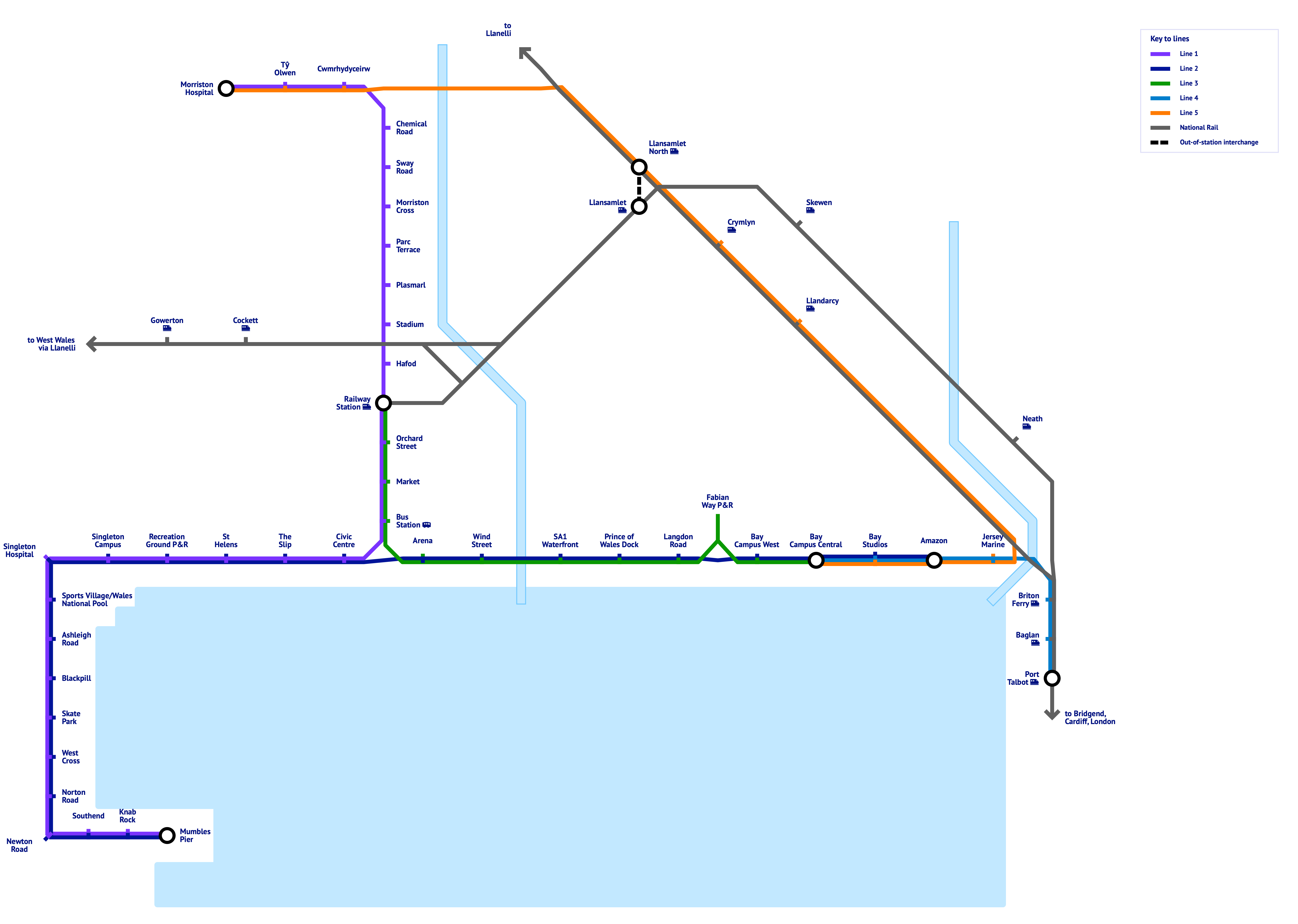
Phase 1
In most cities with universities, the universities are significant origins and destinations for public transport trips, so any tram system should take these in. In Swansea specifically, the land near the Bay Campus is also the most promising location for a tram depot, being both underused and used for light industry. As discussed in the introduction, the connectivity between the railway station and bus station is currently awful, so it would be ideal for Phase 1 to fix this issue as well, so that travellers arriving into Swansea by train have better options to get to the rest of the city.
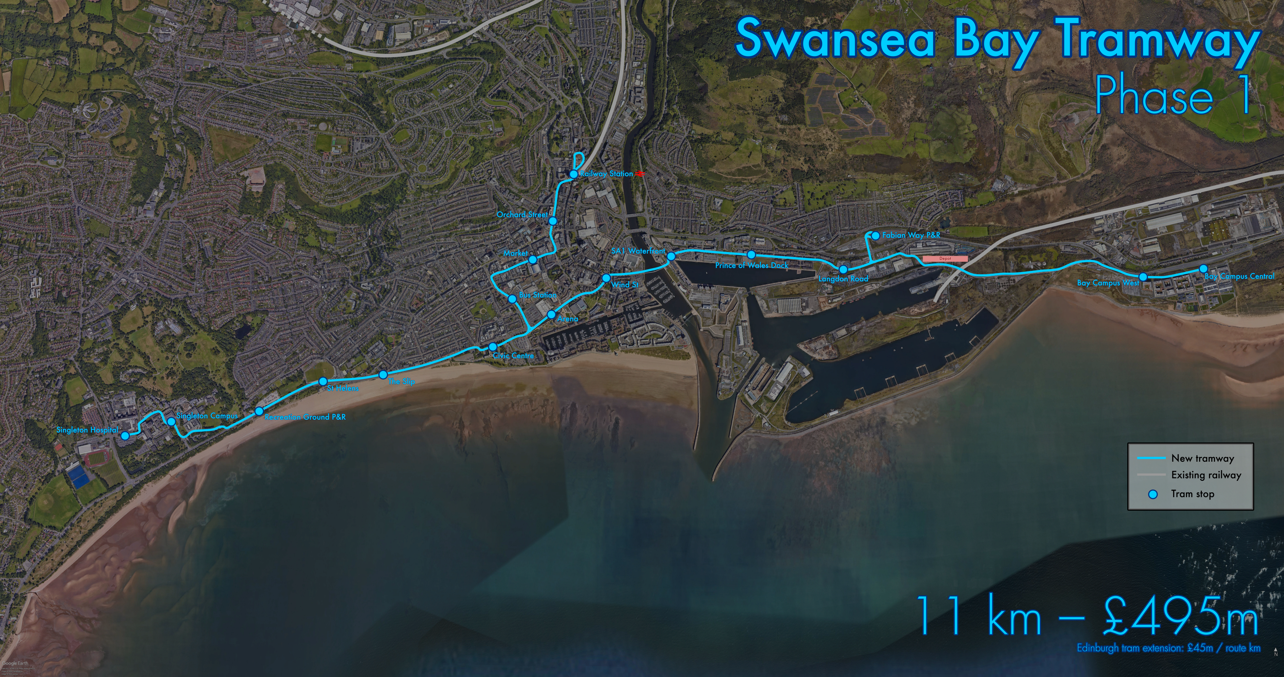
We start at Singleton Hospital, since for the extra few hundred metres of track from the University campus, it will enable significantly more journeys from hospital staff and patients. We then take the busway into Swansea University’s Singleton Campus, and then follow the campus access road to exit at the east side of campus. (This skips a relatively congested part of Mumbles Road.) Following the route of the since-abandoned ftrmetro, we then head east, calling at the Recreation Ground Park and Ride site, the stadium at St Helen’s (for Brynmill), the old Slip bridge (for the Brangwyn Hall and Sandfields), and the Civic Centre, again using the access road. Some portion of this route would need on-street running, but some may be able to be separated out, with some creative rearrangement of the pavements and lanes.
To the east of the Civic Centre we have a triangle junction, through which for now we will take the east branch. This calls at the Arena and Wind Street, before cutting through south of Sainsbury’s and crossing the Tawe over a new bridge into SA1. (While the postcode area is much larger, encompassing most of the city centre, SA1 is also used to refer to the redeveloped docklands to the east of the Tawe.) A stop at what I’ve called SA1 Waterfront captures traffic to and from the new student accommodation, some of the new University of Wales facilities, and the startups encouraged to set up shop there. Continuing through SA1, we call at Prince of Wales Dock and Langdon Road, before reaching a spur to the Fabian Way Park and Ride site, requiring a new bridge over Fabian Way.
To the east of the park and ride is where I would suggest a good depot site may be, since there is an abundance of brownfield land here. In the absence of other traffic generators, we have an express section eastwards before reaching Swansea University’s Bay Campus, which is long enough to justify two stops, one at the west end near the car park and student accommodation, and one near the main road entrance giving access to the engineering and science buildings, which would be the terminus of phase 1.
Going back to the fork near the Civic Centre, the northward branch would continue the ftrmetro route to the bus station, before turning east down Oxford Street (rather than continuing up to the Kingsway), where we call at the Market. Oxford Street is currently partially pedestrianised, which would allow a tramway to better avoid traffic, and arguably has more traffic sources and sinks on it. Turning left at the end of Oxford Street, we head up Orchard Street (while going along the High Street may be better in terms of destinations, the left turn would be very tight, and the road is too narrow to get good traffic flow unless private cars were banned on this stretch). Bearing right at the end of Orchard Street, we reach the other terminus, the railway station.
Trams could operate three routes, Singleton–Bay Campus, Singleton Campus–Railway station, and Railway station–Bay Campus, all of which would have value.
This route would require 11km of dual track in total. Basing costs on a recent UK tram project, the Edinburgh tram extension, which cost £45 million per route kilometre of dual track, this would give a total cost of £495 million.
Phase 2
Phase 2 seeks to replicate what was once available from the Mumbles Train. Mumbles Road is incredibly congested on a typical summer’s day, and parking in Mumbles is awful; having a way to move larger numbers of people there more efficiently will be invaluable.
Rather than head down the very congested Sketty Lane, we head west from Singleton Hospital, through the University Sports Village, stopping at the Wales National Pool. From there, we head down Cwm Farm Lane to rejoin Mumbles Road before calling at Ashleigh Road. (Since we will be the wrong side of Mumbles Road here, either some reconfiguration will be needed to provide enough space to the north of the road for a dual-track tramway, or a new road crossing will be needed. The road junction with Derwen Fawr Road has long been identified as needing improvement, so the best option may be to have the tramway cross Mumbles Road as part of a new roundabout or other new junction there.)
From Ashleigh Road, we follow the route of the old Mumbles Railway and the current Mumbles Road; if we are to avoid taking over the promenade pedestrian footpath and cycleway, then we will need some sections of on-street running, but there should be enough room for a decent amount to be dedicated tramway, albeit by taking up some of the green space currently separating the road from the cycleway. The tram way could be kept as grass, however, similarly to in Grenoble and Brno, which would minimise disruption to the greenery.
After Blackpill, we stop at the Skate Park that briefly went viral while still in development, West Cross and Norton Road for local homes and shops, Newton Road for the main Mumbles shops, Southend for the Mumbles bars and restaurants, Knab Rock for Verdi’s, and finally Mumbles Pier.
One issue here is the lack of a good space to turn around at the terminus, so drivers would need to change ends, and there may be uneven wear on vehicles. Provided there other termini on the network have a turnaround (as the railway station does in phase 1), this doesn’t seem to be catastrophic.
This extension is 6km of double track, with an estimated cost of £270 million.
Phase 3
Phase 3 comes in two parts:
- Phase 3a: A tram-train extension east from Swansea University’s Bay Campus, and
- Phase 3b: A tram extension north from Swansea railway station.

Phase 3a
From Bay Campus Central, the tramway heads east along the existing access road, and cross Fabian Way at the existing junction. After calling at Bay Studios and Amazon (another significant sink for passengers), it then joins the currently freight-only branch line coming out of the Port of Swansea, which joins the Swansea District Line after a new station at Jersey Marine village. This will allow tram-train operation along two branches: one east to the existing stations at Briton Ferry, Baglan, and Port Talbot, and one west to new stations at Llandarcy, Crymlyn, and Llansamlet North, the latter of which with an out-of-station interchange to the current Llansamlet station on the South Wales Main Line, before joining up with Phase 3b at Cwmrhydyceirw. (The Swansea District Line is in tunnel at the site of the current Llansamlet station, so it is somewhat impractical to expand the existing station with new platforms; the new station would be perhaps 200m to the north.)
The tram-train sections have a much lower density of stations than the tramway, owing both to needing to still work as train lines, and to passing through much more sparsely-populated areas.
Only 1.6km of new double-track would be needed for this phase, requiring £72m, plus the costs of new stations and tram-trains.
Phase 3b
This route continues following the route of the former ftrmetro and current number 4 bus route.
Starting from the railway station, where the reversing loop from Phase 1 could be retained to allow the city centre section to be more intensively worked than this extension, the tramway heads north along the current busway to a stop at the Hafod. From there, it calls at the Stadium, Plasmarl, Parc Terrace, Morriston Cross, and Sway Road, before a sharp left turn to Chemical Road. Much of this section must run on street, due to the density of the surrounding terraces. After crossing the Swansea District Line, the tramway is joined by tram-trains from Phase 3a, and then crosses the M4 using either the existing bridge or a new parallel one. It turns to the west, running adjacent to Heol Maes Eglwys briefly, before turning north up Heol y Fran to enter the Morriston Hospital grounds from the back. It makes two calls, one at Tŷ Olwen, and one at Morriston Hospital’s main patient entrance, after which there is space for a reversing loop around the car park.
This is longer than Phase 3a, needing 7.7km of new dual-track tramway, with an estimated cost of £347 million.
Future options
Since posting the above maps on Discord, I’ve encountered others’ crayons, including the amazing website of Adrian Beasley.
One option I neglected, but having walked it today could be possible, is reinstating the line from Blackpill to Gowerton through Killay and Dunvant. Swansea Council have recently been clearing vegetation to the sides of the path, revealing that there is likely sufficient room for a single-track tramway, possibly with passing loops, in addition to the current footpath/cycle path. This would give much better connectivity to non-coastal West Swansea.
There is also work ongoing to improve the main route from the City Centre to Sketty, Walter Road and Sketty Road, a route which historically had a tramway, so has very wide roads and pavements. The current work is to narrow the roads to make room for cycleways, but reinstating trams along this route could also be possible; if extended further, this could meet up with the previous proposal in Dunvant, and potentially reduce the congestion around Olchfa School at school pickup and dropoff times.
Conclusion

It’s one tramway, Michael. What could it cost, a billion pounds?
The costs of this are significantly higher than bringing back the ftrmetro. Of course, the potential benefits are higher as well, but are they high enough given this cost? Likely not. But does this mean that trams aren’t worthwhile, or that there is something wrong with construction in this country such that tramways are too expensive to build compared with our European neighbours?